A place for the different and unusual relating to: Space and Science, Conspiracy Theories, Paranormal Activity, or anything else 'outside the box'.
Wednesday, December 29, 2010
Doomsday seed vault
The Global seed vault, also known as the doomsday vault was built on the Norwegian island of Spitsbergen in 2008 at a cost of around $9,000,000 US.World government's have deposited over 10,000 seed samples. The area was considered ideal due to its lack of tectonic activity and its permafrost. There are numerous conspiracy theories associated with this vault, some of which I most likely will post in future blogs.
Thursday, December 16, 2010
Canadian Roswell: Ottawa River UFO Crash
This event literally occured in my backyard a few kilometres from my house on July 27th 2009. I was not around at the time but did a thorough search of the area a few day's later. Some people claim the US army were first on the scene.
Wednesday, December 8, 2010
Chemtrails: AEROSOL CRIMES & COVER UP?
In 1996, a chemtrail conspiracy theory began to circulate when the United States Air Force was accused of "spraying the US population with mysterious substances". The existence of chemtrails has been repeatedly denied by government agencies around the world. The chemicals are described as barium and aluminum salts, polymer fibers, thorium, or silicon carbide. It is alleged by some that the skies are being seeded with electrical conductive materials as part of a massive electromagnetic superweapons program based around the High Frequency Active Auroral Research Program. Other conspiracy's include weapons testing, global warming prevention measures as well as New World Order depopulation agenda. Again, I am not one to prove or debunk any of this, but one thing that I have noticed in recent years is the fact that more and more people are getting sick more frequently, not only aging baby-boomers, but young adults and especially babies and young children. One only has to look at stats from the last 40 or 50 years to see the difference. And that, regardless of the reason, should be cause for concern.
Wednesday, December 1, 2010
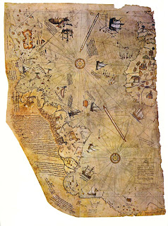
Piri Reis map
 Turkish historians discovered an old map in a Palace in 1929. The map was imprinted on an old animal skin and dated 1513. Here comes the mystery, the map apparently depicted large part of the Atlantic ocean, including the America's as well as Antarctica. According to history books, Antarctica was not discovered till 1818. One of the mystery surrounding this map is its accuracy, so accurate was the map that experts from the US air force in the 1960's used it to replace false information on their own charts. The continent of Antarctica was not mapped till 1949 by a British-Scandinavian group using modern day equipment to scan under mile-deep ice. Some experts suggest that Antarctica was ice free around 6,000 years ago
Thursday, November 25, 2010
Wednesday, November 24, 2010
Shag Harbour
A trip to the East Coast of Canada would not be complete without a drive through the small fishing village of Shag Harbour, Nova Scotia, site of the 1967 UFO incident. A dozen or so eyewitnesses reported seeing a large light crashing into the harbour around 11.30 pm. The RCMP were dispatched soon after thinking an airplane might have crashed in the ocean. Upon arriving at the site, police found a trail of yellow foam floating on the water.Today, no known RCMP reports of this sighting remain.
Monday, November 22, 2010
Ancient artifact
On a trip to Dominican Republic in the early 1990's, I came across a very old man in the village of Luperon selling odd stuff, among those items was a small stone carving I thought would make an ideal souvenir. Well it seems I have finally solved the riddle of the mysterious bat head carving. The Taino people (13th–15th century) would create distinctive ceramic vessels, often with handles shaped as bat heads used in burial ceremonies.
Saturday, November 20, 2010
Friday, November 19, 2010
UFO Landing Sight
With my mother and sister near Chapeau, Quebec, where a 32 feet (9.75 m) wide circular imprint was found in the ground, with a ring of scorched grass 2.5 feet (0.76 m) wide, containing three indentations forming an equilateral triangle, with sides 15 feet (4.57 m) long, each dent 8 inches (20.3 cm) wide and 3 inches (7.6 cm) deep, suggesting a "landing tripod". A second smaller circle was also found, with a ring of scorched grass.
Thursday, November 18, 2010
Day 2
I am amazed at the fact that the meter on my page is showing 18 views after a mere 24 hours of being created. Perhaps the "men in black" are spying on me to make sure that the truth stays out there, lol! This page is still in its infancy and I look forward to building and adding more details soon.
Wednesday, November 17, 2010
Night Vision Anomalies at Brown Mtn. Oct. 13, 2009
I travelled to North Carolina with my family as a child, but unfortunately the lights never appeared when we were there.
Subscribe to:
Posts (Atom)


